Pfannknecht Via Ferrata

Moderate
open
Mountaineering · Klettersteig
04:15 h duration
5,70 km Length in km
2816 m Highest point
2158 m Lowest point
675 m gain Ascent
675 m gain Descent
Stamina
Difficulty
Adventure
Scenery

Tour description

An alpine via ferrata on the south ridge of the Pfannknecht, featuring exposed sections, natural climbing, and impressive views over the Jamtal.

The Pfannknecht via ferrata winds through an unspoiled high-mountain landscape above the Jamtalhütte. Passing over boulder fields and former glacial areas, you’ll reach the Pfannknechtscharte, where the actual via ferrata begins. The route follows the exposed south ridge and is rated at difficulty level C. There are hardly any ladders or artificial footholds, so you’ll be climbing mostly on natural rock. This route requires sure-footedness, a head for heights, alpine experience, and confidence in using via ferrata equipment. At the highest point, you’ll find a small summit cross, a summit logbook, and a sweeping view over the Jamtal valley. The descent leads back down the east side to the Jamtalhütte.

Start - Directions - Descent

Starting Point

From the parking lot above the Mentaalm, follow the access road—which is closed to public traffic—into the Jamtal valley. The route runs along the Jambach stream, past Alpele, Schnapfenalm, and Scheibenalpe, all the way to the Jamtalhütte at 2,165 meters. The approach to the hut is also suitable for mountain bikes or e-mountain bikes. If biking, plan on about 1 hour and 20 minutes; on foot, about 3 hours and 15 minutes.
From the Jamtalhütte, head south at first and follow the signs toward Pfannknecht or Chalausferner. After crossing the stream, leave the trail leading to the glacier and ascend the slope to the left. Faded markings and cairns indicate the way forward.
Crossing a mountain ridge and traversing extensive scree and boulder fields, you’ll reach the former glacial basin. The route then leads through a wide scree hollow and over possible remnants of old snow up to the Pfannknecht Saddle. From the Jamtal Hut, you should allow about 1.5 hours for this section.

Route Description

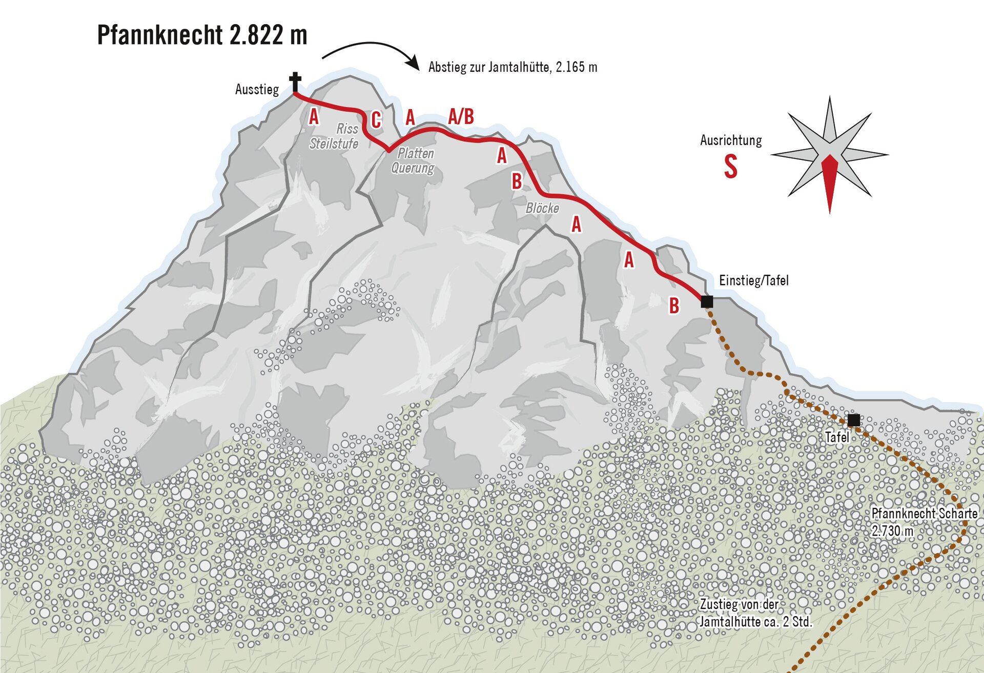
This alpine via ferrata follows the south ridge of the Pfannknecht and is rated difficulty level C. There are hardly any artificial aids such as ladders or foothold clamps. You’ll be climbing mostly on natural rock and using the continuous steel cable for guidance.
At the start, the route leads over a rocky outcrop and then crosses to the other side of the ridge. This is followed by a dihedral, a diagonal traverse across a slab, and several exposed rock sections.
The final section runs along a narrow and exposed ridge to the rocky peak, where you’ll find a summit logbook and a small metal cross. You should plan on spending about 30 minutes on the via ferrata itself.

Descent
From the summit, you first descend northward via sections secured with wire ropes. The route then leads over steep scree and possible patches of old snow down the eastern flank. Below a prominent rocky hump, keep to the right and continue descending to the valley floor. You then follow the clearly visible trail along the Futschölbach stream back to the Jamtalhütte. From the hut, you return to the parking lot via the same access road.

Getting to the starting point

Due to the long-term closure of the Silvretta-Hochalpenstraße, the Silvretta-Bielerhöhe is currently accessible only via the Vermuntbahn and the tunnel bus. We therefore recommend using the Vermuntbahn’s valley station in Partenen as your starting point. Please check the current operating hours.

From Partenen, take the Vermuntbahn uphill and then continue on the tunnel bus to the Bielerhöhe. From there, you can take public transportation to Galtür.

Alternative:
By e-bike via Ganifer and Kops to Galtür

By public transportation

The Montafon regional bus and the Montafonerbahn offer a convenient and flexible way to get around the valley. Trains and buses connect the towns regularly, every half hour or every hour depending on the route. You can find suitable connections in the cleVVVer mobil schedule app.

Bus stop for the start and end of this tour: Partenen Bergbahnen.

By car
Take the A14 to the Bludenz/Montafon exit. Then follow the Montafonerstraße L188 to Partenen. Parking is available at the Vermuntbahn and Tafamuntbahn stations.

Important Information

You climb the via ferrata at your own risk and on your own responsibility. Please check the weather, current conditions, snow conditions, and difficulty level in advance. Realistically assess your experience, surefootedness, ability to handle heights, and physical fitness.

A complete set of standard-compliant via ferrata equipment is absolutely essential. This includes a hip belt, via ferrata set, helmet, and gloves. Equally important is appropriate footwear: sturdy, ankle-high hiking boots with good traction.

Your backpack should also include plenty of food, sun and rain protection, and a first-aid kit.

In the Montafon, you can rent high-quality via ferrata equipment at select sports shops. Please check in advance regarding availability, sizes, and reservation options.

Sicherheitstipps für Wandern in Vorarlberg

EN NOTRUF:

EN 140 - Alpine Notfälle österreichweit 

EN 144 - Alpine Notfälle Vorarlberg 

EN 112 - Euro-Notruf (funktioniert mit jedem Handy/Netz) 

Properties
Route type Mountaineering, Klettersteig
Difficulty Moderate
Elevation profile
Best months
Jan
Feb
Mar
Apr
May
Jun
Jul
Aug
Sep
Oct
Nov
Dec